FAQ: The effects of WNC’s 2016 fire season
Did the fires hurt wildlife?
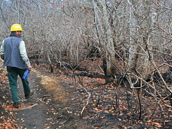
Prescribed burning is often used as a tool to benefit wildlife by regenerating their habitat, and in the case of the slowly creeping ground fires that accounted for most of the burned area, wildlife are usually able to get out of the way as flames approach.
However, not all species are that mobile. The noonday globe snail, listed as threatened, is the focus of significant concern. The species is only known to inhabit a 99-acre area of the Nantahala Gorge, and 85 percent of those acres burned. Wildlife biologists are still assessing how the fire might have impacted its population, or if the species has some kind of mechanism — such as burrowing — available to avoid the flames.
In the short-term, other wildlife species could face hardship from the fires, Wilkins said.
“Parts of that, I’m sure it had a huge impact because you basically eliminated most of the winter forage, whether it’s acorns that are on the ground still edible or those forbs and things and other brush species that would help carry them through the winter,” he said. “I’m sure it’s had a localized impact.”
However, that impact would be unlikely be large enough to affect overall populations, Wilkins said, and long-term the fires will result in a flush of green in the understory that will ultimately benefit wildlife.
Related Items

More chronic wasting disease cases recorded

Jackson County hosts BirdFest

Don’t loosen floodplain restrictions

Rock climbing restrictions will protect young falcons
Will the fires increase the chance to flooding and landslides?
The Forest Service’s Burned Area Report identified several areas where there is a high risk of flooding or landslides due to loss of vegetation and water-repellent soil.
However, with more than a month elapsed since the report’s Dec. 12 completion and multiple heavy rains in the rear-view mirror, there haven’t seemed to be any issues. Many areas that the team completing the report initially observed to have water-repellent soil seem to be absorbing water much more readily.
“Even after these rain events we did not see much soil movement or erosion potential from the hydrophobic soils,” Kauffman said.
The report included a list of risks resulting from the fires, color-coding them by severity. Areas listed as being at a high risk for flooding or landslides were:
• Nelson Ridge Road and Vineyard Road. Increased risk of flooding.
• Locust Tree Road, Crawford Cove Road, Wayah Bald Road. Increased risk of flooding.
• Poplar Cove Road. Increased risk of landslides and flooding.
• Winding Stairs Road. Increased risk of landslides and flooding, as well as hazard trees, debris and rolling rocks.
• Partridge Road. Increased risk of landslides and flooding.
Is a spring fire season likely?
Typically, spring fire seasons tend to be more severe than fall fire seasons. The humidity is lower, winds are gustier, and the sap flowing through the trees makes them more volatile, Wilkins said.
So, while fuels are pretty wet right now, the region is still in drought. The potential for a spring fire season will depend on what the weather does over the coming months.
“We could hope for a normal or light season, but right now they’re predicting the potential for a drier than normal spring,” Wilkins said.
In the Asheville office, Public Information Office Cathy Dowd is preparing for just that possibility, compiling information about key contacts, the area’s fire history and firewise behavior to have at the ready. The last time the region saw a significant fall fire season, in 2007, a significant spring fire season followed.
“Everybody’s really keeping an eye on the weather and the drought because we could also go into fire restrictions again,” Dowd said.
To a degree, though, the fire season could depend on the scruples of people in the area. Of the 20-plus fires that burned through WNC last fall, only one is thought to have resulted from natural causes. The rest were caused by humans, either accidentally or on purpose. All the fires are currently under investigation.
How did the fires affect the Appalachian Trail?
South of the Smokies, 58 miles of the A.T. run through North Carolina and are maintained by the Nantahala Hiking Club. Of those 58 miles, 26 miles were part of the burned area, said Bill Van Horn, a member and past president of NHC.
Of those 26 miles, about 90 percent experienced pretty mild burning, Van Horn said, about the same level you’d get with a prescribed burn. However, about 10 percent burned hot, consuming wooden anti-erosion features on the trail and creating hazards like holes in the ground and dead trees.
“We’ll be working on it probably for a good six months, and that will put off some of our other normal maintenance,” Van Horn said.
NHC volunteers go out every Wednesday to work on trail maintenance, and the pieces of the trail most affected by the fire are also the most remote — with the time it takes to drive and then hike to the trouble spot, an eight-hour day yields only about four hours of work.
One of the fire-induced trouble spots sits halfway between the Nantahala Outdoor Center and Tellico Gap, where a set of about 20 wooden steps on a switchback were burned. Because the area requires a 4-mile hike to reach, rebuilding the steps will require a significant investment of time and energy.
Then there are the hazardous holes created when the fire consumed tree stumps that the trail’s original builders left in the ground when the A.T. was first built, back in the 1930s.
“Once it started burning it burned slowly and it burned completely, so instead of having that wooden stump there you have nothing but ash,” Van Horn said. “When the rain comes it just compacts it and we have to deal with these holes.”
The holes can create a hazard for hikers, who might inadvertently plunge a foot into them while carrying a heavy pack. The NHC is working to find any ash-filled stump holes out there.
On the whole, though, the A.T. didn’t come out too badly, Van Horn said.
“We were lucky,” he said. “We had 10 shelters out there and 10 privies and none of them were damaged. That was due totally, I think, to the Forest Service going in there before the fire got there.”
Were any structures lost?
Despite more than 150 homes being evacuated as flames advanced, a hunting cabin near Wayah Bald was the only casualty on private lands near the Nantahala National Forest.
However, the Forest Service itself did see some notable losses. The wooden boardwalk at Whitewater Falls near Cashiers burned completely, leading the Forest Service to close the area indefinitely until the walkway can be rebuilt.
“It burned up almost everything. We just wondered if maybe the person who started it put some gasoline or something on the wood, just torched it,” said Gary Kauffman, botanist for the Forest Service. “That’s going to take quite a while to fix and it’s very expensive, so the trail there may be closed for a year.”
The Forest Service has secured funding to rebuild the walkway, said Nantahala District Ranger Mike Wilkins, and it’s hoping for the project to be done by July 1. The price tag is likely to run between $150,000 and $200,000.
About 55,000 people visit Whitewater Falls each year, and it’s “one of our county’s greatest assets” for tourism, said the Jackson’s tourism director Nick Breedlove.
However, he doesn’t expect the temporary closure to have too much impact on the county’s ability to bring in tourists, as Jackson isn’t in short supply when it comes to impressive waterfalls.
“That’s one of the jewels of our county, but we have several other falls close by,” he said.
The fire also burned the roof off of the historic Wayah Bald Lookout Tower. No money has yet been appropriated for that project, and Wilkins said he has no estimate for how much it might cost. However, a local timber framer has offered to donate the labor, and some other folks have offered to supply materials in a public-private partnership to rebuild the site — firmer plans should be in hand within the month.
The Forest Service also lost six interpretative signs, which will cost about $800 apiece to replace.
Did the fire create many of those open spaces that some people want the forest management plan to prescribe for the Pisgah-Nantahala?
The contentious forest planning process has been underway for years now, and one of the central points has been disagreement over the need for more young forest habitat — also referred to as early successional — in the forest. Some believe that the proportion of young forest habitat is way too low and hindering the health of wildlife populations, particularly of game species, while others believe that protecting existing old-growth forest should be the priority.
Either way, it doesn’t seem that the fires moved the needle in terms of existing conditions.
“I would say the amount (of young forest habitat) the fires created would certainly be less than 5 percent, maybe less than 1 percent, of the fire area,” Kauffman said.
The fire was mostly a slow-moving, low-intensity affair. It will likely benefit fire-adapted tree species, reinvigorate plant growth and reduce the risk of wildfire reigniting those same areas for a number of years — but it didn’t create too many meadows.
“The fires didn’t affect what we want the forest to be in the future, nor did they have an immediate effect on the steps we need to take in that direction,” said Michelle Aldridge, planning officer for the Forest Service.
While the Forest Service will incorporate new information on the burn’s impacts into the plan as it goes along, there’s no call to go backwards in the process, Aldridge said.
The fires will have at least one impact on the planning process, however. Many of the same staff responsible for helping develop the plan were called out to respond to the fires, so staff lost about two months of time that ordinarily would have been devoted to developing the plan. In addition, just before fire season hit the Forest Service decided to add an additional chapter to the plan, one that looks at particular “special places” that people mentioned in their comments. While the current timeline calls for a draft plan to be released this spring, Aldrige says late summer is now the earliest the document will be released, and it might not be ready until fall.
“It’s not just fire season that’s causing the delay,” she said. “It’s a strengthening of the plan, and we think it’s more important to take that time now than to wait and have those discussions later.”
What is on the Forest Service’s to do list this spring?
Rehabilitating fire lines will be a big task for the Nantahala Ranger District as the weather warms up. While firefighters made significant headway toward naturalizing the dug-up lines as fire season wound down, there are still about 30 miles of fire line that need to be dealt with, Wilkins said.
“We tried to prioritize before the weather shut us down to get those areas near live water, but that’s a pretty big job and on that steeper ground, once it gets really wet for the winter it just doesn’t dry out,” he said.
Especially on steep slopes, non-rehabilitated fire lines lead to erosion, as there are no roots or leaves covering them to stop water from flushing the dirt downhill. They can also open up the forest to invasive plants, whose seeds can easily take root in the bare soil. The forest canopy overhead helps protect fire lines from that threat, but it’s still a consideration, Wilkins said. The rehabilitation process will involve renting track hoes, contracting with operators to drag brush and leaves back over the fire lines, and seeding the area with native plants. Because the need for rehabilitation is directly related to the fire, the same fund that paid for fire suppression will fund the work — a separate pot from the district’s regular budget.
Rehabilitating fire lines isn’t the only item on Wilkins’ to do list. Many of the district’s roads took a pretty good beating from bearing heavy equipment all fall. And because the fire burned through two timber sale areas that were already sold, the Forest Service will have to make some adjustments to those contracts.
The Forest Service will also be addressing threats from invasive species in areas other than fire lines. Across nine fires, the Forest Service received $55,000 to prevent their spread, primarily by using herbicide.