Wildfire season 2023: live updates
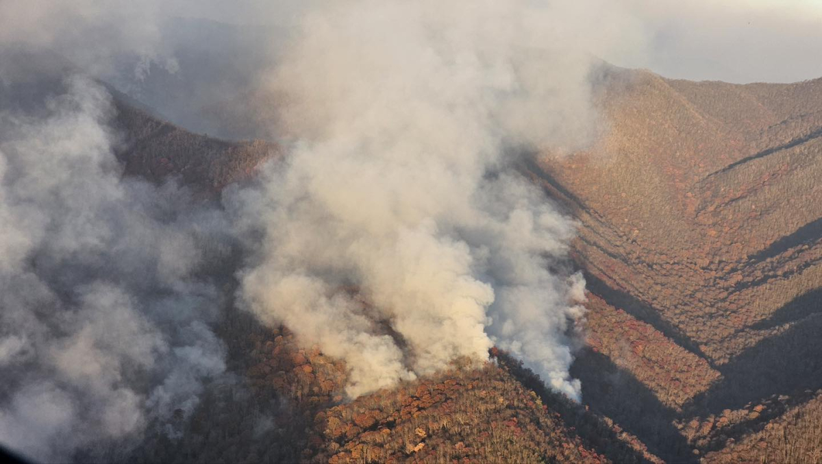 Smoke fills the valleys surrounding the Collett Ridge Fire. USFS photo
After months of dry weather, drought is translating into wildfires and burn bans.
Friday, Dec. 1
5:26 p.m. — Fire activity increases
After calming down with the rains preceding Thanksgiving, fire activity in the area has increased over the last week.
The Black Bear Fire in Haywood County, now 90% contained, has seen new activity today. The fire has crossed Snowbird Creek and is moving toward the ridgeline. Forest visitors, hikers on nearby sections of the Appalachian Trail, and anyone traveling through the Interstate 40 corridor should proceed with caution. Smoke is drifting throughout the area and may affect travel and nearby communities in North Carolina and Tennessee. Brown Gap Road remains closed for firefighter safety.
Meanwhile, two fires are burning in McDowell County. The Locust Cove #2 Fire, which is burning within the fire scar of the Locust Cove Fire that burned a larger area in March, is estimated at between 165 acres and is 0% contained. The Clear Creek Fire, burning nearby the Locust Cove #2 fire, is estimated at 124 acres and 0% contained.
While the new drought map released yesterday shows improvement in drought conditions, the area is still extremely dry, and fire danger remains high.
Related Items

Slow burn: NC 107 work marches on

Are the ‘deniers’ practicing better science?

Lawsuit challenges Forest Service timber targets

Prescribed burns scheduled for Cataloochee
Friday, Nov. 24
2:35 p.m. — Closure area lifts near Black Bear Fire
Most of the closure area surrounding the Black Bear Fire in Haywood County has now been lifted, allowing people to once again enjoy popular areas like Max Patch and the Appalachian Trail nearby.
Brown Gap Road will remain closed for firefighter safety, as crews are continuing to work nearby, but the rest of the closure area is now open. According to the most recently available update, the fire is now 79% contained at 1,888 acres.
Wednesday, Nov. 22
6:53 p.m. — Tips requested in Smokies arson investigation
An initial investigation indicates that two fires started on Nov. 20 in the Rich Mountain area of the Great Smoky Mountains National Park were arson, and the park is looking for help identifying those responsible.
The Rich Mountain Fire was reported on Nov. 20 around 2:30 p.m. near the intersection of Old Cades Cove Road and Rich Mountain Road. The fire prompted an early-morning voluntary evacuation of homes near the park boundary on Nov. 21. The fire is now 100% contained, with 31 personnel assigned who will continue to mop up and monitor it through the weekend.
“Intentionally setting fires in the park, except in designated rings or picnic areas, is always illegal and is extremely dangerous, especially under the extreme weather conditions we saw this week,” said Boone Vandzura, Chief Ranger of Resource and Visitor Protection. “We are asking visitors and neighbors for help as we work to identify those responsible for this suspected arson.”
A white truck was seen at the Rich Mountain trailhead on Nov. 20 around 10 a.m. This vehicle may not be involved in the incident, but the occupants may have seen something and have information that can assist the investigation.
The National Park Service is asking anyone with information that could help identify those responsible for the arson to submit a tip. Tips can be submitted anonymously, and a financial reward is available for validated tips.
To submit a tip, call or text, 888.653.0009, visit go.nps.gov/SubmitATip or email This email address is being protected from spambots. You need JavaScript enabled to view it..
6:25 p.m. — County, national forest burn bans lifted
Burn bans have been lifted across the region following steady rains throughout the day Tuesday and into Wednesday morning.
At 5 p.m. today, the N.C. Forest Service lifted its burn ban on 30 western counties and the U.S. Forest Service lifted the burn ban that had been in effect for the Pisgah and Nantahala national forests.
“The forests received 1-2 inches of widespread rainfall over the past 48 hours, effectively reducing fire danger,” reads the announcement from the USFS. “The rain was also beneficial to the current fires, Collett Ridge and Black Bear, resulting in no additional fire growth and minimal activity.”
The USFS issued what will be the last updates for those fires “unless significant fire activity occurs.” The Collett Ridge Fire is 100% contained at 5,505 acres and the Black Bear Fire is 79% contained at 1,888 acres. The closure order previously issued for the Black Bear Fire remains in effect.
While the rain was enough to lift the burn bans, it’s not near enough to lift the area out of drought.
The most recent drought map, released today and based on precipitation reported as of 8 a.m. Tuesday, shows drought conditions markedly expanding across the state. Currently, 13 western counties are in extreme drought, up from nine last week, with the list now including Burke, Jackson, Lincoln, Swain, Cherokee, Clay, Cleveland, Graham, Henderson, Macon, Polk, Rutherford and Transylvania counties. Meanwhile, 40 counties are in severe drought and 27 are in moderate drought. An additional 16 counties are abnormally dry.
These drought designations exclude much of the precipitation that fell with the system that arrived early Tuesday morning. Mid-week rainfall would be reflected in next week’s drought update but is expected to mainly have the effect of preventing drought conditions from worsening.
“Typically, rain for this time a year is about an inch a week,” said Klaus Albertin, chair of Drought Management Advisory Council. “If we get an inch and a half, it could help, but may not improve conditions dramatically. The mid- to long-term forecast is still for a wet winter due to the El Niño pattern, but it’s expected to be January before we start to see big impacts.”
Tuesday, Nov. 21
 3:11 p.m. — Rain is falling, but fire season persists
Rain is finally falling all across the region, but that doesn’t mean that the fire season is over or burn bans lifted.
“The weather we are receiving is helping to moderate or slow fire activity and growth on the current fires. However, it is not a season-ending event rather it’s more of a slowing event, it’s slowing the pace of fire activity and growth,” said Adrianne Rubiaco, fire public affairs specialist for the U.S. Forest Service.
While the rain is wetting many smaller fuels, such as leaf litter, larger fuels such as logs continue to hold heat.
“This decrease in activity is giving many of our local firefighters and resources the opportunity to rest and take some much needed time off as we receive additional support from resources and personnel from out west,” Rubiaco said.
Weather over the next few weeks will determine the direction of this fire season, said Corey Davis, assistant state climatologist for the N.C. State Climate Office.
“If we were to get back into a warm and dry pattern, then this rain could be only temporary relief, and some of the same areas could dry out again and see another spell of late-season fire activity,” he said. “Fortunately, the outlook for the next 8 to 14 days is showing cooler temperatures likely for North Carolina with slightly better chances of above-normal precipitation, so that risk of conditions drying out again should be lower.”
Currently, soils are dry 5 to 7 inches below the surface, so hot spots could continue burning and smoldering even after the rain passes. However, the rain will almost certainly help contain fires that are already burning. Even less than half an inch of rain a couple weeks ago helped push the Collett Ridge Fire from 5% containment to more than 50%.

The Rich Mountain Fire, as seen from a webcam on Look Rock Nov. 20. NPS photo
9:15 a.m. — Voluntary evacuations take place as Rich Mountain Fire grows
Late last night, firefighters mapped a new blaze in the Great Smoky Mountains National Park near Rich Mountain Road and estimated its size at less than 2 acres. By 2 a.m. winds from the south had caused it to grow to about 6 acres. The fire is burning in steep, rugged terrain, primarily within the park boundary.
Yesterday, a helicopter was used until dusk to deliver water for suppression efforts. In addition, Townsend Volunteer Fire Department and Blount County supported the initial response.
Today, firefighters are continuing to improve line around the fire. Current resources include two Tennessee Department of Forestry dozers, the park’s Wildland Fire module with seven crew members, a type-6 engine from Cherokee National Forest with four crew members and the park’s type-6 engine with two crew members.
The National Park Service has ordered additional resources, including air support and more engines. If conditions allow, air resources will be used today to assist fire resources in suppression efforts.
Blount County coordinated an early-morning voluntary evacuation of homes near the park boundary. High wind and red flag warnings remain in effect for the area until later today. Several roads and campgrounds within the park remain closed for employee and visitor safety. A parkwide burn ban is also in effect until further notice.
Monday, Nov. 20
7:33 p.m. Fire starts in the Great Smoky Mountains National Park
Firefighters are responding to a wildfire near Rich Mountain Road in the Great Smoky Mountains National Park, currently estimated at 5-7 acres. No structures are threatened, and the cause of the fire is under investigation.
A helicopter will drop water on the fire this evening before anticipated high winds move into the area and ground air operations. Firefighters are working to secure line around the fire and will stay on the scene overnight. Responding resources include National Park Service personnel, Townsend Fire Department and the Tennessee Department of Forestry.
This is one of several fires that have started in the park recently. At 11 a.m. today, a construction crew working on Lakeview Drive near Bryson City witnessed a woman set two fires to grass and brush on the road shoulder. The fires were both quickly extinguished before they could grow. The woman was arrested, and state and federal charges are pending. On Sunday night, firefighters from Blount County put out a small brush fire at Look Rock. The fire’s cause is under investigation. The National Park Service thanks Swain County, the North Carolina Forest Service, and Blount County for their quick response.
Very strong winds are expected in the park this evening, especially on the Tennessee side, with gusts of 60-80 mph. A Red Flag Warning remains in place. The National Park Service has closed several campgrounds and roads throughout the park today. A burn ban remains in place throughout the park.
Intentionally setting fires, except in designated rings in camping or picnic areas, is always illegal in national parks. Intentionally starting fires under high wind and red flag warnings is illegal, dangerous and irresponsible. Under red flag conditions, fire danger is elevated and strong winds will cause fires to spread rapidly.
5:24 p.m. — Cooper issues expanded State of Emergency
Gov. Roy Cooper has expanded the State of Emergency declared Nov. 8 in response to ongoing wildfires in Western North Carolina to include additional counties, as drought conditions and elevated fire risk continue throughout the state.
The expanded order adds Anson, Caswell, Davidson, Davie, Forsyth, Guilford, Montgomery, Moore, Randolph, Richmond, Rockingham, Scotland, Stanly, Stokes, Surry and Yadkin counties to the existing area that includes Alexander, Alleghany, Ashe, Avery, Buncombe, Burke, Cabarrus, Caldwell, Catawba, Cherokee, Clay, Cleveland, Gaston, Graham, Haywood, Henderson, Iredell, Jackson, Lincoln, Macon, Madison, McDowell, Mecklenburg, Mitchell, Polk, Rowan, Rutherford, Swain, Transylvania, Union, Watauga, Wilkes and Yancey counties as well as Eastern Band of Cherokee Indians tribal lands.
“The expanded state of emergency will continue to extend support to local jurisdictions and partner agencies impacted by the ongoing wildfires with the resources they need,” said Will Ray, Director of North Carolina Emergency Management. “We ask that all North Carolinians do their part by following guidance from North Carolina Forest Service and public safety officials for wildfire safety, especially while these drought conditions continue. If we all do our part to prevent wildfires, and other preventable disasters, we will be protecting our communities and the first responders who work in them.”
Read Executive Order No. 294 here.
11:41 a.m. — Smokies issues closures in face of heightened fire danger
Visitors to the Great Smoky Mountains National Park should leave as soon as possible in advance of severe weather, dangerously high winds and a red flag warning signaling heightened fire danger.
Campgrounds in Elkmont and Cades Cove within the Great Smoky Mountains National Park are now closed, and many roads within the park have closed as well or will close later this afternoon.
“Employee and visitor safety is our only priority,” said Superintendent Cassius Cash. “We understand these closures are an inconvenience, but we are trying to eliminate as much risk as possible during this dangerous weather event.”
Newfound Gap Road, also known as U.S. 441, will close around 1 p.m. today between Sugarlands Visitor Center and Smokemont Campground. Additional roads that have already closed or will close later this afternoon include Clingmans Dome Road, Cherokee Orchard Road and Roaring Fork Motor Nature Trail, Foothills Parkway between Walland and Wears Valley, Little River Road between the Townsend Wye to Sugarlands Visitor Center, Laurel Creek Road and Cades Cove Loop Road, Cataloochee Road and Lakeview Drive.
Gatlinburg Bypass, Foothills Parkway West (from Look Rock to U.S. 129), and other park roads will remain open as long as safely possible. The Spur will remain open as long as safe vehicle passage exists.
Winds will grow stronger this afternoon and overnight with sustained winds at 40 miles per hour and hurricane-force gusts. A red flag warning is in effect for the Smokies, which means very low humidity and stronger winds are expected to combine to produce an increased risk of fire danger. A burn ban is currently in place in the park, which prohibits all campfires and charcoal use until further notice.
Visitors should exercise extreme caution, check the park website for alerts and heed warnings from the National Weather Service and local emergency managers when making travel plans. Hikers should avoid hiking during the high wind warning.
Campgrounds, facilities and roads will remain closed until the high wind and red flag warnings have expired and park rangers can assess roads and facilities. The National Park Service will issue an afternoon update on Tuesday, November 21, on the status of campgrounds and roads in the park.
 A map shows the boundaries of the newly enacted closure area around the Black Bear Fire in Haywood County. USFS map
10:09 a.m. — Windy forecast prompts caution; closure issued around Black Bear Fire
Firefighters made significant progress on existing wildfires this weekend as the region anticipates the arrival on Tuesday of what could be its biggest rainfall in two months.
Rainfall of up to an inch is expected for much of the mountain region, with spotty rain today becoming widespread overnight, according to the National Weather Service. However, strong winds are expected to precede the rain. A high wind watch is in effect for the east Tennessee mountains and foothills Monday afternoon through Tuesday afternoon, with gusts up to 70 miles per hour possible. Such gusts could cause current fires to escape containment and spark new fires from downed trees and power lines. A fire weather watch is in effect through Tuesday morning for the area covered by the National Weather Service station in Morristown, Tennessee, which includes eastern Tennessee and Clay and Cherokee counties in North Carolina.
“PLEASE PLEASE PLEASE take extreme caution today & tomorrow as the historically dry conditions combined with gusty winds can lead to fires burning out of control QUICKLY,” reads a Facebook post the station published this morning. “The Appalachian mountains and foothills will likely have the worst fire weather conditions today. Even something as simple as a cigarette out the car window could lead to a devastating wildfire.”
The Black Bear Fire in Haywood County has grown to 1,720 acres but is now 42% contained. Primary containment lines are I-40 to the southwest, the Appalachian Trail to the north and Forest Service Road 3580 on the east south to I-40. As of the last update, 193 people were assigned to the fire. Wet weather Friday night helped firefighters get ahead of the blaze, giving them an opportunity to put containment lines in place and plan ahead before the return of drier conditions.
The fire has prompted an emergency closure order from the U.S. Forest Service, with affected lands in the Appalachian Ranger District of the Pisgah National Forest and Unanka Ranger District of the Cherokee National Forest closed to all entry. The order will remain in effect through Dec. 31, or until rescinded by an authorized Forest Service official.
Only National Forest System lands are impacted by the closure. The A.T. is closed from 1-40 to Brown Gap including Groundhog Creek shelter. On the Pisgah National Forest, the closure includes the area west of Cold Springs Creek Road and Browns Gap Road, south of the A.T. and north of I-40 to the state line. On the Cherokee National Forest, the closure includes the area north of I-40 to Carmichael Tract Road and south of Carmichael Tract Road, Snowbird road and Brown Gap Road to the state line.
The only exemptions from this closure are for people with a permit specifically authorizing entry or for any federal, state or local officer, or member of an organized rescue or firefighting force in the performance of an official duty. Violation is punishable by a fine of up to $5,000 for an individual or $10,000 for an organization, up to six months in prison or both.
In Cherokee and Clay counties, the Collett Ridge Fire remains at 5,505 acres and is 82% contained. The Poplar Drive Fire in Henderson County has reached 100% containment at 434 acres. The Bullet and Tweed fires on the Cherokee National Forest are now 40% and 85% contained, respectively. Fires that popped up over the weekend in Clay and Buncombe counties were quickly contained and kept to low acreages.
The entire area is under a burn ban. Burning is not allowed for any reason, and fines will be issued to those who violate the ban.
Saturday, Nov. 18

The Black Bear Fire as seen from I-40. USFS photo
5:28 p.m. New fires start in WNC
The N.C. Forest Service’s wildfire map shows two new fires in Western North Carolina. A 1.5-acre fire has started near the Georgia state line in Clay County, just east of Chatuge Lake, and a 5-acre fire has started in southern Buncombe County. Both are 0% contained.
As of the last available update, the Black Bear Fire in Haywood County is 1,193 acres and 0% contained, with 166 people on the scene. Firefighters plan to use I-40 the Appalachian Trail and Forest Service Road 3580 as primary containment lines. Containment line work along the A.T. will consist of raking away leaves and twigs and removing fallen trees, both activities that take place during normal trail maintenance.
“Last night’s wet weather is giving firefighters an excellent opportunity to put containment lines in place, as well as for fire managers to work with local county, state and federal agencies to plan for drier conditions conducive to fire spread beginning this weekend through early next week before additional rainfall occurs later in the week,” reads an update the U.S. Forest Service posted this morning.
Unless fire fuels were wetted by rain, surface fuels will support very active fire spread with slope and wind. Heavy fuel concentrations will cause flare-ups and accelerated spread rates. Fire behavior characteristics for the day include wind and slope-aligned head fire spread, including fingering runs on steep slopes. Expect active flanking fire with potential head runs. Sustained backing may produce slope reversals in creek bottoms.
Expect smoke when traveling I-40 near the fire, which is located at mile marker 3 near the Tennessee state line. No evacuations are in place at this time, but several closures remain. The A.T. is closed from I-40 to Max Patch, and road closures are in effect for Cold Springs Road and Brown Gap Road. Impacts to travel along I-40 are expected.
The Collett Ridge Fire, burning in Cherokee and Clay counties, remains at 5,505 acres and is now 82% contained. The Poplar Drive Fire in Henderson County remains 98% contained at 434 acres. The fire, which destroyed multiple structures, including a home, was determined to be caused by a debris burn.
As of Nov. 17, 769 fires have burned statewide since Nov. 1.
Friday, Nov. 17

The Black Bear Fire, as seen from the sky. U.S. Forest Service photo
4:08 p.m. — Black Bear Fire swells
The Black Bear Fire in Haywood County has grown to 1,193 acres after starting yesterday morning in connection with a tractor-trailer accident on Interstate 40, 3 miles from the Tennessee state line. The fire spread north of the highway, rapidly progressing up steep slopes with southeast winds.
The fire is 0% contained and prompting a closure of the Appalachian Trail from I-40 to Max Patch, with road closures in effect for Cold Springs Road and Brown Gap Road. Impacts to travel along I-40 are expected. However, the fire is not currently threatening any structures.
Crews are assessing the area for the construction of primary, alternate and contingency control hand and dozer lines from I-40 north to the Tennessee state line, as well as identifying needs for structural protection and other values at risk. Additional firefighting resources have been requested and are enroute.
Surface fuels, steep slopes and wind will support very active fire spread. Heavy fuel concentrations will cause flare-ups and accelerated fire spread rates. Fire behavior characteristics for the day include wind and slope-aligned head fire spread, including fingering runs on steep slopes. Expect active flanking fire with potential head runs. Sustained backing may produce additional head runs in creek bottoms.
A cold front approaching the region today will bring increasing clouds with wetting showers tonight, starting after sunset, with rainfall of one-quarter to half an inch expected overnight. Clouds and showers may linger into the morning Saturday before clearing in the afternoon.
The Southern Area Blue Incident Management Team has assumed command of the fire after transitioning away from the Collett Ridge Fire in Cherokee County, which is now 80% contained at 5,505 acres. The U.S. Forest Service’s National Forests of North Carolina has assumed command of that incident. Crews will continue to monitor and patrol, perform mop-up operations such as extinguishing any lingering hotspots, and remain available to respond to any new fires. Smoke will continue to be visible as forest floor fuels and snags continue to smolder.
On that fire, closures are in effect in the area from Big Stamp east to Shinbone Ridge to Signal Bald and a road closure is in effect from the intersection of Little Fires Creek Road, 340B, and Fires Creek Road, 340. The Rim Trail is temporarily closed for approximately 7 miles from Big Stamp to Shinbone.
The Poplar Drive Fire in Henderson County is now 98% contained at 434 acres. One home, two cabins, one uninhabitable mobile home, one uninhabitable cabin and two outbuildings were destroyed. One home was damaged. Firefighters continue to reinforce containment lines and target any smoldering pockets that remain. The cause of the fire was determined to be a debris burn.
The Bullet Fire in Monroe County, Tennessee, remains at 103 acres. The Mill Mountain Fire in Sumter National Forest in South Carolina is 100% contained at 990 acres, and all associated closures have been lifted.
Thursday, Nov. 16
4:27 p.m. — Campfires banned in Great Smoky Mountains National Park
All campfires and charcoal use are now banned throughout the Great Smoky Mountains National Park, escalating a ban issued Nov. 6 that applied only to backcountry fires. The ban will remain in effect until further notice.
Campers, backpackers and picnic area users may continue to use cookstoves with compressed gas canisters and gas grills that have an on/off switch. These must be attended at all times.
3:14 p.m. —Black Bear Fire in Haywood grows to 150 acres
Mere hours after igniting following a traffic accident this morning, the Black Bear Fire in Haywood County has swelled to 150 acres and is 0% contained.
As a result, the Appalachian Trail is closed from Interstate 40 to Max Patch. Road closures are in effect for Cold Springs Road and Brown Mountain Road. Impacts to travel along Interstate 40 are expected. Check current road conditions at drivenc.gov.
The fire, reported around 9 a.m., began following a tractor-trailer accident at mile marker 3 on Interstate 40 in Haywood County and is burning on rugged terrain on U.S. Forest Service land in the Appalachian Ranger District of the Pisgah National Forest.
The U.S. Forest Service and N.C. Forest Service are responding to the fire, and the Southern Area Blue Team, currently assigned to the Collett Ridge Fire in Cherokee County, will assume command once it arrives on scene. Personnel and equipment on the incident include air attack, air tankers, helicopters, a 20-person hand crew and dozers. Aircraft are conducting retardant and water drops to slow the fire progression. The fire is very active, moving up a ridge through dry fuels.
The public can expect to see smoke when driving along I-40 near the fire, today and through the night. Aircraft and drones are not allowed in the fire area. Burn bans are in place across the region as Western Carolina continues to experience a serious drought situation.
12:55 p.m. Haywood fire approaches the A.T. 
A satellite image shows the fire as of Nov. 16.
Any hikers on the Appalachian Trail near I-40 should leave immediately and seek safety now due to a wildfire that began this morning along Interstate 40 in County and is now approaching the A.T. Do not enter the A.T. between I-40 and Brown Gap.
The fire originally started following a tractor-trailer accident at 8:30 a.m. this morning about 3 miles from the Tennessee state line on I-40 in North Carolina.
11:43 a.m.
The fire that started this morning in Haywood County is now about 40 acres and showing active fire behavior as it moves up a ridge through dry fuels, the U.S. Forest Service says.
The fire sparked along I-40, about 3 miles from the Tennessee state line, following an accident involving a tractor-trailer. It is burning on U.S. Forest Service lands on the Appalachian Ranger District of the Pisgah National Forest.
The U.S. Forest Service and N.C. Forest Service are responding with resources including an air tanker, helicopter, hand crew and dozers.
10:57 a.m. Accident sparks Haywood County wildfire
A traffic accident on Interstate 40 in Haywood County has sparked a wildfire that currently measures about 5 acres.
The accident, which occurred around 8:30 a.m. this morning, involved a tractor-trailer in the Pigeon River Gorge, about 3 miles from the Tennessee line, said Allison Richmond, public information officer for Haywood County Emergency Services. The fire is on U.S. Forest Service land and is not near any populated areas, so no structures are currently in danger.
Currently, fire crews from Tennessee, the N.C. Forest Service and the U.S. Forest Service are on scene, with Haywood County crews en route.
10:36 a.m. WNC experiences extreme drought for first time in six years
For the first time since March 2017, as the region eased out of the historic drought that spawned the 2016 wildfire season, parts of North Carolina are experiencing extreme drought.
Nine counties are included in this designation: Macon, Cherokee, Clay, Graham, Henderson, Transylvania, Cleveland, Polk and Rutherford. Severe drought has expanded into the northern mountains, encompassing an additional 30 counties. An additional 40 counties are in moderate drought and 17 are abnormally dry.
While the areas of the southern mountains received up to half an inch of rain over the weekend, seasonal precipitation deficits continue to grow. Currently, 71.6% of the state is in moderate drought or worse, the most since late December 2021. Though scattered showers are possible Friday night and Saturday, better chances for rain are expected with a cold front arriving next Tuesday and Wednesday. Between half an inch and 2 inches of rain is possible.
While the weekend’s rain didn’t make a dent in the drought, it did help firefighters control existing blazes. According to the most recent available numbers, the Collett Ridge Fire near Andrews is now 80% contained at 5,447 acres, the Poplar Drive Fire in Henderson County is 98% contained at 434 acres and the Alum Knob Fire in Madison County is 100% contained at 36 acres.
In the Cherokee National Forest in Tennessee, the Tweed Fire in Greene and Cocke counties is 60% contained at 536 acres, the Buck Bald Fire in Polk County is 60% contained at 573 acresand the Bullet Fire in Monroe County is 20% contained at 103 acres.
In the Sumter National Forest in South Carolina, the Mill Mountain Fire west of Lake Jocassee is 100% contained at 990 acres.
Monday, Nov. 13
 10:44 a.m. New fires reported in Madison County
While existing wildfires saw marked gains in containment over the weekend, two new fires have popped up in Madison County.
According to the N.C. Forest Service’s wildfire map, these include a 36-acre fire between Whiterock and Allenstand, which is 40% contained, and a 4.4-acre fire north of Worley, which is 0% contained.
The Collett Ridge Fire remains at 5,335 acres and is now 55% contained, with 271 people assigned to it. Weather helped firefighters increase containment on the fire yesterday. A drone was used to conduct aerial reconnaissance to identify heat signatures within the fire area. Heat sources from larger smoldering fuels, such as snags, stumps and dead-and-down trees, were identified well inside the fire perimeter.
Hand line work will continue along Polecat Branch to connect with the containment line along the southern edge of the fire. Firefighters will be reducing forest fuels around residences in the Whispering Pines area as a protection measure. Crews continue to patrol the northern, eastern, and southern edges of the fire area and perform mop-up operations, extinguishing any lingering hotspots, as needed.
The Poplar Drive Fire in Henderson County is now 75% contained at 434 acres. In the Cherokee National Forest in Tennessee, the 300-acre Tweed Fire straddling Cocke and Greene Counties is 10% contained, the 540-acre Buck Bald Fire in Polk County 3 miles north of Farner is 60% contained and the 103-acre Bullet Fire in Monroe County is 20% contained.
While rain and high humidity over the weekend aided in firefighting, warmer and drier conditions are expected to take hold this week. This will increase the challenge for firefighters and raise the danger of new fires starting amid the region’s ongoing drought. Burn bans are in place across the region.
Saturday, Nov. 11
12:12 p.m. — Humidity, light rain aid in firefighting
The Collett Ridge Fire grew only moderately yesterday, now measuring 5,335 acres, and has leapt from 0% to 15% containment. Currently, 244 personnel are assigned to the incident.
Progress has also been made on the Poplar Drive Fire in Henderson County, which remains at 434 acres and is now 50% contained.
Fire behavior was moderated yesterday due to the cold front that brought cloud cover, cooler temperatures, increased humidity and light precipitation. On Nov. 10, Murphy received 0.05 inches of rain.
Today’s forecast calls for these conditions to through Sunday morning. Until sufficient rain occurs, fire activity and growth are expected to continue with areas of heavy fuels potentially causing flareups.
Firefighters on the Collett Ridge Fire will continue to build and improve containment lines in the area of Snider’s Creek Road and McClellan Road today to the northwest of the fire. Engines remained on scene throughout the night to provide point protection for structures. Crews will patrol near the communities of Bolden Branch and Lord’s Way and perform mop-up operations, such as extinguishing any lingering hotspots, as needed.
To the northeast of the fire in the Kimsey Cove area, hand lines were completed, and crews will take advantage of the fire-moderating weather to work on contingency lines to the east. Fire activity along Shinbone Ridge on the southern edge of the fire has been minimal, and fire managers anticipate patrol and mop-up operations to begin soon.
Resources assigned to the fire include, five 20-person hand crews, Type 4 and 6 engines; dozers; and water tenders. Aerial resources include three helicopters.
Friday, Nov. 10
4:58 p.m. Clouds and rain lead to progress on Cherokee National Forest fires
The Cherokee National Forest in Tennessee currently has three active wildfires.
Updates as of 2 p.m.:
-
The Tweed Fire in Cocke and Greene Counties, 13 miles southwest of Greenville, Tennessee, is currently 80 acres. Crews continue to make progress on building fire lines. The fire is being investigated as human caused.
-
The Buck Bald Fire in Polk County, 3 miles north of Farner, is 450 acres and 50% contained. No structures are immediately threatened by this fire and no significant activity reported. The Forest Service is aided by crews from Americorps, the Bureau of Land Management and other out-of-state firefighters. The fire is being investigated as arson.
-
The Bullet Fire in Monroe County, 5 miles southeast of Etowah, Tennessee, I 103 acres and 20% contained. Fire activity is minimal, but because it is burning in steep inaccessible terrain, fire crews are using indirect tactics to control fire spread. Firefighters from Mount Vernon, Conasauga and Tennessee Division of Forestry assisted with structure protection for structures in the immediate area of the wildfire. The cause of this fire remains under investigation.
2:11 p.m. — Progress continues on Poplar Drive Fire
The Poplar Drive Fire in Henderson County has grown only minimally over the last few days and is now 30% contained at 434 acres. There are 199 people responding to the blaze.
One home, two cabins and two outbuildings have been lost, while another home sustained damage. Area homes remain threatened, and Forest Service personnel, county fire department and sheriff’s office staff are continually assessing the needs of those structures. The cause of the fire remains under investigation. Two firefighters sustained minor injuries, and both were treated and released. One minor motor vehicle accident has been reported with no injuries.
Yesterday’s strategic firing operation along Kyles Creek Road was a success, strengthening containment lines along the western boundary. Today firefighters continue to mop-up smoldering pockets around the fire, using water handling equipment for spraying water and hand tools for exposing heat within the duff soil layer.
“The mop-up process is going to take some time, but we have a drone flying the fire at night to find the greatest sources of heat and we are trying our best to tackle those with as much water and personnel as possible,” said Operations Section Chief Dwayne Vigil. “The rhododendron and brush are thick and still have a good bit of leaves on. The soil around the roots is loose due to the fire eating away the organic material around those roots, causing them to be weak. If the vegetation falls over and the leaves fall onto the smoldering areas, the fire could reignite and throw embers. In some areas the vegetation is so thick, firefighters have to cut their way into the brush to get to the heat to put water on it.”
Fire activity is currently low intensity within the fire perimter, but potential for reignition is high due to leaf fall and snags. Though rain is expected this weekend, it is not forecast to be significant, and warm, dry weather is predicted to return next week.
Personnel with the N.C. Forest Service, N.C. Emergency Management, Office of State Fire Marshal, Henderson County Emergency Management, Henderson County Sheriff’s Office, Edneyville Fire Department along with numerous other fire departments from across the state are responding to the incident.
Burn bans are in place, and a temporary flight restriction has been issued in the fire area from the surface up to 7,500 feet in elevation. Drones are unlawful in this area.
2:02 p.m. — DuPont wildfire contained
A wildfire that broke out this week along Cascade Lake Road in DuPont State Recreational Forest has been 100% contained at 36.5 acres.
The fire crews have finished the mop up stage and have moved to patrol stage. They will visit the area each day, keep the leaves off the lines, and make sure the fire does not reignite.
“Friends of DuPont Forest is so very grateful for all of the crews out there protecting DuPont Forest, including the DuPont Forest Service staff,” said Sara Landry, executive director of Friends of DuPont. “Big thank you to Lucia Gedes and her Cedar Mountain Cafe staff for providing lunch for the crews this week.”
Sheep Mountain Trail remains closed. Cascade Trail is closed between Staton Road and Cascade Lake Road.
New management in place for Collett Ridge Fire as blaze continues to grow
The Collett Ridge Fire has grown to 5,116 acres and remains 5% contained, with 178 people now responding. Since a lightning strike started it Oct. 23, the fire had been under unified command from the U.S. Forest Service and N.C. Forest Service, but today the Southern Area Blue Incident Management Team, from the interagency Southern Area Coordination Center, assumed command.
Firefighters are assessing structure protection needs for communities to the northwest of the fire, in the McClellan Creek area. Engines remain on scene throughout the night to provide point protection as needed. Crews continue to establish handline and dozer lines to the northwest of the fire from Snyder Creek to Polecat Creek. To the south, firefighters are strengthening and securing the containment line along Fires Creek Road and when weather permits are using strategic firing operations to reduce unburned vegetation between the fire and the containment line. Crews are finishing handline to the northeast in the Kimsey Cove area. To the north, firefighters continue to patrol the area near the communities of Bolden Branch and Lord’s Way and perform mop-up operations, such as extinguishing any lingering hotspots, as needed.
Resources assigned to the fire include three 20-person hand crews, Type 4 and 6 engines; dozers; and water tenders. Aerial resources include helicopters and fixed wing aircraft.
A road closure is in effect from the intersection of Little Fires Creek Road, 340B, and Fires Creek Road, 340. The Rim Trail is temporarily closed for approximately 7 miles from Big Stamp to Shinbone.
Fire bans remain in place throughout Western North Carolina, including bans on backcountry fires on public lands. A Temporary Flight Restriction is in place over the Collett Ridge Fire area. Aircraft or drone intrusions into the restricted airspace endanger aircrews conducting fire operations, and aerial resources are grounded for safety.
Light rain, humidity, clouds and cooler temperature are expected over the fire area today, a trend that will continue through the weekend with the possibility of light rain Sunday. Until sufficient rain falls, fire activity and growth are expected to continue with areas of heavy fuels potentially causing flareups.
Smoke may occur in nearby communities. Air quality information provided by the North Carolina Department of Environmental Quality is available at www.airquality.climate.ncsu.edu/.
Thursday, Nov. 9
5:02 p.m. — Cherokee National Forest restricts backcountry fires as wildfires burn
Wildfire activity has continued to increase on the Cherokee National Forest in Tennessee, prompting minor restrictions, road closures and trail reroutes. The national forest has announced a ban on backcountry fires outside of those in designated fire rings, grills or gas stoves, to reduce the rusk of further wildfires.
Wildfire updates as of 2 p.m. are:
-
The 60-acre Tweed Fire, located in Cocke County, Tennessee, 13 miles southwest of Greenville, Tennessee, is 5% contained. Structures are threatened by this wildfire and structure protection mitigations are ongoing. Forest Service hotshot crews are responding alongside resources from Tennessee Division of Forestry, Greene County Sheriff's Office and Greene County Fire and rescue. Helicopters are aiding firefighters with water bucket drops. This wildfire is being investigated as human caused.
-
The 350-acre Buck Bald Fire, located 3 miles north of Farner, Tennessee, in Polk County, is 50% contained. No structures are immediately threatened by this fire. The Forest Service is aided by crews from Americorps, the Bureau of Land Management, and out of state firefighters. This wildfire is being investigated as arson.
-
The 103-acre Bullett Fire, located 5 miles southeast of Etowah, Tennessee, in Monroe County, is 20% contained. The fire is burning in steep inaccessible terrain and fire crews are using indirect tactics to control fire spread. Current fire activity is minimal. Firefighters from Mount Vernon VFD, Conasauga VFD and Tennessee Division of Forestry assisted with structure protection in the immediate area of the wildfire. The cause of this wildfire remains under investigation.
-
The Hogum Hollow Fire, located 2 miles southwest of Roan Mountain, is now contained. Tennessee Division of Forestry and Cherokee National Forest resources continue to monitor this area.
11:23 a.m. — Collett Ridge Fire surpasses 4,000 acres

The Collett Ridge Fire near Andrews is now threatening 16 structures after growing to 4,372 acres with only 5% containment.
The threatened structures are on the northeastern side of the fire, and firefighters are on scene working to protect them.
Yesterday firefighters established containment lines and began clearing leafy debris from around homes and buildings and cutting back any overhanging branches to prepare the structures to be more resilient if the fire comes close. Crews patrolled the burned area to the north of the fire near the communities of Lord’s Way/Bolden Branch, and no hotspots were detected. Firefighters began scouting potential locations for containment lines to the west of the fire within the Snyders Creek and McClellan Creek areas. The southern portion of the fire was burning to the north of Tathum Cabin Branch and northwest of County Corners. Aircraft was used to slow the progression of the fire to the west using 33,000 gallons of water, which was drawn from Nantahala Lake.
Today firefighters will continue strengthening handlines to the northeast of the fire and providing structure protection as needed. Crews will begin constructing handlines on the northwest side of the fire within the Snyder Creek and McClellan Creek areas to tie into a dozer line along the western side south to Big Stamp. On the southern side firefighters are working to keep the fire to the north of Fires Creek Road and may perform firing operations as conditions allow near Cold Springs Branch and Shinbone Ridge.
Despite increased humidity today, dry conditions will persist due to increased temperatures, with fire activity and growth expected to continue. Light rain is forecast to start Friday.
Cherokee, Clay and Macon counties may experience Code Red air quality conditions, defined as air that is unhealthy for anyone to breathe. Residents should consider limiting prolonged or heavy exertion outdoors in these areas. Anyone sensitive to air pollution, including children, older adults and people with asthma, should avoid outdoor exertion. Air quality information available at airquality.climate.ncsu.edu/.
There are no evacuation orders at this time. However, road and area closures are in effect due to increased fire activity and suppression operations in the area from Big Stamp east to Shinbone Ridge to Signal Bald, and a road closure is in effect from the intersection of Little Fires Creek Road, 340B, and Fires Creek Road, 340. The Rim Trail is temporarily closed for approximately 7 miles from Big Stamp to Shinbone.
No structures have been lost and no first responders have been injured. There are 156 people on scene, with resources including three 20-person hand crews, 13 Engines, one water tender, one dozer, two helicopters, one air attack platform, and overhead personnel. The fire is under unified command from the U.S. Forest Service and N.C. Forest Service.
10:40 a.m. — Severe drought conditions expand across the state
 The number of counties in severe drought has more than doubled to 31 in the newest drought map released this morning.
The list of counties experiencing severe drought now includes Alexander, Anson, Burke, Cabarrus, Caldwell, Catawba, Cherokee, Clay, Cleveland, Davie, Gaston, Graham, Henderson, Hoke, Iredell, Jackson, Lincoln, Macon, McDowell, Mecklenburg, Moore, Polk, Richmond, Robeson, Rowan, Rutherford, Scotland, Swain, Transylvania, Union and Yadkin. An additional 39 counties are in moderate drought and 26 counties are abnormally dry. This leaves only five counties not experiencing abnormally dry or drought conditions, all located in the eastern part of the state.
Last week saw essentially no measurable rainfall across the state, along with warmer temperatures and lower humidity levels that accelerated the drying of soils and fuels. Together with the leaf drop, that led to nearly 400 wildfires igniting on state and private lands.
A cold front is expected to move in tomorrow, then stall to the south this weekend, bringing some rain to North Carolina. Periods of showers are expected over the weekend, but totals will be generally limited to between a quarter and half an inch — well below what is needed to quell drought conditions in the mountains.
10:20 a.m. — Blue Ridge Parkway issues burn ban
Backcountry campfires are now banned on Blue Ridge Parkway lands in response to an ongoing drought and active wildfire season.
Fire restrictions apply to all backcountry campsites and shelters, and do not affect front country, year-round picnic areas. Fires in developed areas must always be confined to designated fire rings and grills. Picnickers should reduce the risk of wildfires by extinguishing fires completely until ashes are cool to the touch.
The backcountry fire ban joins similar bans already in place in the Great Smoky Mountains National Park, Pisgah National Forest and Nantahala National Forest. The N.C. Forest Service has banned open burning more than 100 feet away from a residence in the state’s 30 westernmost counties. In some counties, local burn bans also outlaw open burning within 100 feet of a residence. These counties include Haywood, Jackson, Macon, Cherokee, Buncombe, Transylvania and Henderson.
10:11 a.m. — Cooper declares State of Emergency
Gov. Roy Cooper declared a state of emergency Wednesday, Nov. 8, as wildfires burn in Western North Carolina amid an expanding drought.
“I am grateful for the first responders who have jumped into action to help combat the ongoing wildfires in Western North Carolina,” Cooper said. “The fires and the continued droughts across the state pose a risk to public health and safety and we want to ensure that all residents and their property remain safe and protected."
Three wildfires are currently active in the western region: the 3,918 Collett Ridge Fire near Andrews (0% contained), the 36.5-acre Cascade Lake Road Fire in Transylvania County (50% contained) and the 431-acre Poplar Drive Fire in Henderson County (5% contained). A 310-acre fire East Fork Fire in Jackson County is now 80% contained and designated as controlled.
“The current wildfires, combined with the ongoing drought and weather forecast have increased our risk for additional fire activity, especially in the western part of our state,” said Will Ray, director of North Carolina Emergency Management.
The State of Emergency will coordinate and support emergency response operations among North Carolina entities and officials to ensure the protection and safety of North Carolina residents.
The emergency area includes Alexander, Alleghany, Ashe, Avery, Buncombe, Burke, Cabarrus, Caldwell, Catawba, Cherokee, Clay, Cleveland, Gaston, Graham, Haywood, Henderson, Iredell, Jackson, Lincoln, Macon, Madison, McDowell, Mecklenburg, Mitchell, Polk, Rowan, Rutherford, Swain, Transylvania, Union, Watauga, Wilkes and Yancey counties as well as tribal lands in the State of North Carolina held by the Eastern Band of Cherokee Indians.
Read Executive Order No. 293, which institutes the state of emergency, here.
Wednesday, Nov. 8
2:29 p.m. — Possible arson causes fires in Cherokee National Forest
A cluster of fires in the Cherokee National Forest near Famer, Tennessee, managed together as Buck Bald Fire, are being investigated as arson. Meanwhile, two additional wildfires are burning in the national forest. These fires are:
-
Hogum Hollo, 44 acres, North Zone, 2 miles southwest of Roan Mountain
-
Bullet, 78 acres, South Zone, 5 miles southeast of Etowah
-
Buck Bald, 140 acres, South Zone, 2 miles north of Famer
“We’re seeing a rapid increase in wildfires across the forest placing people, homes and infrastructure at great risk,” said Stephanie Bland, deputy forest supervisor with the Cherokee National Forest. “Human-caused fires take valuable resources away from the protection of people and structures making dry conditions much more dangerous for everyone.”
Wildland firefighters are working night and day on each of these fires to contain spread. Crews are using existing roads and terrain features to block the spread of wildfire with the aid of water drops from aircraft. Some structures are at risk as these fires spread to private property. The Forest Service is working with private property owners to protect structures.
Wildland firefighters ask the public to help by reporting suspicious behavior to law enforcement.
“We’re investigating multiple fires as arson and our message to the public is if you see something, say something,” said Bland.
Dried fuels remain ready to burn quickly aided by dry conditions that are expected to continue Thursday.
2:06 p.m. — Collett Ridge Fire grows
The Collett Ridge Fire near Andrews has grown about 1,000 acres in the past day, now measuring 3,918 acres.
The fire remains 0% contained, but the 120 firefighters on scene are working to establish lines around its perimeter. Yesterday they started establishing a handline near the Macon/Cherokee county line on the east side of the fire, tying into a dozer line in the Kimsey Cove area. To the south, crews continue to establish a handline off the Rim Trail, and to the southwest handline has been established from Big Stamp to Cold Spring Branch. Aircraft have been used to drop water and fire retardant in an effort to slow the fire’s progressions. The northwest side of the fire is currently burning west of White Oak Knob, along the ridgetop.
Today aircraft will drop water to the northeast, while firefighters work on structure prep within nearby communities and continue establishing handline in the Kimsey Cove area. On the west side of the fire crews will scout the area near Cold Branch, Snyder Branch and McClellan Creek for areas to establish containment lines. Aircraft will be used along the west side to slow the fire progression.
Ongoing drought conditions and unseasonably warm temperatures mean fire activity and growth are expected to continue. Air quality in the area continues to be poor.
No structures have been lost or threatened, and no first responders have been injured. No evacuations have been issued, but some closures are in place. A road closure is in effect from the intersection of Little Fires Creek Road, 340B, and Fires Creek Road, 340. The Rim Trail is temporarily closed for approximately 7 miles from Big Stamp to Shinbone.
1:47 p.m. — Burn bans expand

The N.C. Forest Service has expanded its ban on open burning to include 16 additional counties: Alexander, Alleghany, Ashe, Avery, Buncombe, Caldwell, Catawba, Haywood, Iredell, Lincoln, Madison, Mecklenburg, Mitchell, Watauga, Wilkes and Yancey. These counties join the additional 14 already under a burn ban: Jackson, Macon, Swain, Clay, Graham, Cherokee, Transylvania, Henderson, Burke, Cleveland, Gaston, McDowell, Polk and Rutherford.
The NCFS ban applies to open burning more than 100 feet away from an occupied dwelling. regardless of whether a permit was previously issued. Violations will result in a $100 fine plus $183 in court fees. Any person who sets an illegal fire may be liable for expenses related to extinguishing it.
Some counties have instituted local burn bans that outlaw open burning within 100 feet of a residence. These counties include Haywood, Jackson, Macon, Cherokee, Buncombe, Transylvania and Henderson.
The Great Smoky Mountains National Park, Pisgah National Forest and Nantahala National Forest have all announced a ban on backcountry campfires. In the Smokies, fires are still allowed in developed frontcountry campgrounds and in fire grills at picnic areas. In the national forests, fires are allowed at campgrounds with camp hosts. In both, fuel stoves are allowed.
National forest campgrounds with campground hosts currently include Balsam Lake Lodge, Curtis Creek Campground, Davidson River Campground, Kimsey Creek Group Camp, Lake Powhatan Campground, North Mills River Campground, Sunburst Campground, Standing Indian Campground, and Wolf Ford Horsecamp.
Tuesday, Nov. 7 — Wildfires grow
The Collett Ridge Fire south of Andrews swelled over the weekend, growing from 110 acres Nov. 3 to 2,919 acres Nov. 7 — and still 0% contained.
Meanwhile, the 431-acre East Poplar Fire in Henderson County was only 5% contained as of Nov. 6. In Jackson County, a 310-acre fire west of the Village of Forest Hills was 50% contained as of Nov. 7. In Transylvania County, a 36.5-acre fire in Dupont State Recreational Forest was 75% contained as of Nov. 7.
While no structures have been threatened or damaged in the larger Collett Ridge Fire, as of Nov. 5 the East Poplar fire had damaged two homes, one outbuilding and one uninhabited cabin, also damaging one additional home. The cause of the fire is unknown and under investigation. There are no injuries. Evacuations have been implemented with at least 34 structures currently threatened.
Cherokee, Jackson, Henderson and Transylvania counties are all in severe drought and under a newly enacted open burn ban from the N.C. Forest Service, which prohibits open burning more than 100 feet from a dwelling. All three counties, along with Macon County, have enacted a local ban outlawing fires within 100 feet as well.
On the Collett Ridge Fire, some of the growth is due to burning operations from the firefighters on scene. On Nov. 4, firefighters completed firing operations along Collett Creek and Bolden Creek, reducing the amount of unburned vegetation between the fire and communities to the north. The next day, they burned to the north of the fire along Rattlesnake Ridge to Rattlesnake Knob. However, ongoing drought conditions also contributed to the growth. On Nov. 5, fire activity increased throughout the fire area, resulting in additional growth on all sides. As of Nov. 6, there were 110 people on scene, with resources including two 20-person hand crews, nine engines, two helicopters, one air attack platform and overhead personnel.
With drought conditions ongoing, fire activity is expected to keep increasing. As of Nov. 6, smoky conditions had air quality in the Andrews area rated hazardous, with residents recommended to avoid all outdoor activity. No evacuations or road closures have been announced, but the Rim Trail is temporarily closed for 7 miles, from Big Stump to Shinbone. People should avoid the area so crews can work safely.
Tuesday, Nov. 7 — Burn ban issued
Burn ban issued amid ongoing drought
A burn ban has been issued for 14 Western North Carolina counties in the face of expanding drought following the state’s 10th-driest October since records began in 1895.
According to the most recent drought map from the N.C. Drought Management Advisory Council, based on data collected as of Oct. 31, 14 counties are in severe drought, 47 are in moderate drought and 33 are abnormally dry. The driest conditions occur in the far western region.
The burn ban, which the N.C. Forest Service issued Sunday, Nov. 5, includes all 14 counties under the severe drought designation: Jackson, Macon, Swain, Clay, Graham, Cherokee, Transylvania, Henderson, Burke, Cleveland, Gaston, McDowell, Polk and Rutherford.
The ban prohibits all open burning in these counties more than 100 feet from a residence, regardless of whether a permit was previously issued. Violations will result in a $100 fine plus $183 in court fees.
Some counties, including Jackson, Macon, Cherokee and Henderson, have instituted local burn bans applying to fires close than 100 feet. The Great Smoky Mountains National Park accounced a ban on backcountry campfires.
Any person who sets an illegal fire may be liable for expenses related to extinguishing it. In counties not covered by the burn ban, people should still exercise “extreme caution” when burning, said Agriculture Commissioner Steve Troxler. Much of the state remains dry, and the Forest Service will assess the need to expand the burn ban over the coming weeks.
“Because dry conditions are expected to continue this burn ban is necessary to reduce the risk of fires starting and spreading quickly,” Troxler said. “Our top priority is always to protect lives, property and forestland across the state.”
Many sites in the state received less than an inch of rain throughout October – Asheville, for instance, measured only 0.7 inches, about one-fifth its normal 3.37 inches. Cullowhee’s 1.03 inches was about one-third its normal 3.22 inches, and on the plateau Highlands was even drier, its 1.15 inches just a fraction of its normal 6.47 inches. Dry conditions have continued into November, with multiple wildfires now burning.
“This is one of the top five driest September and October periods on record for much of Western North Carolina,” said Corey Davis, assistant state climatologist with the N.C. State Climate Office.
However, because the region is entering in an El Niño weather pattern this winter, sustained wetter weather is likely in the future.
Temperature-wise, October was a largely seasonal month, with the statewide average temperature of 60.4 degrees equaling the recent 30-year average and making this the 54th-warmest October out of the past 129 years, according to the N.C. State Climate Office.