The last stroke: Forest Service ruling ends Chattooga paddling debate
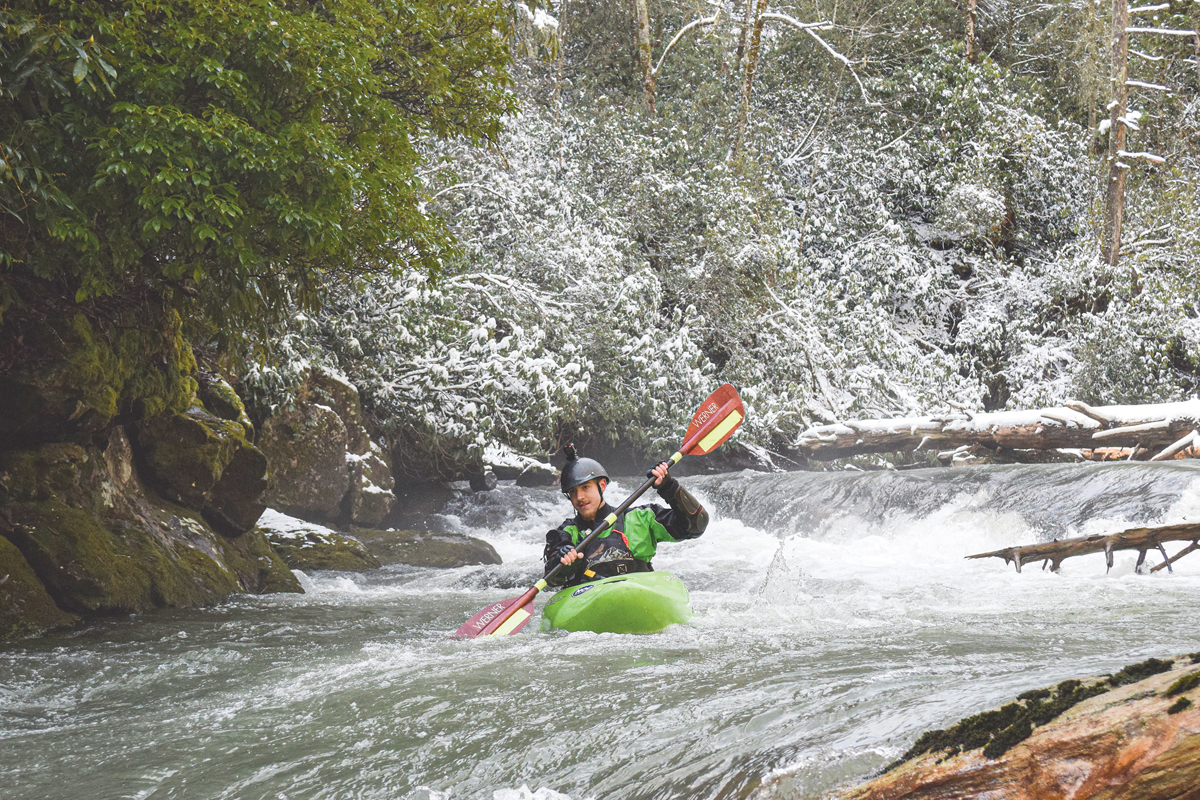 When flows are high, the Upper Chattooga River offers a fun ride to advanced paddlers. Kevin Colburn photo
A decades-long debate over paddling rules on the Upper Chattooga River has come to a close after the appearance of a final ruling in November 2023 took some stakeholders by surprise.
“I’ve never seen a decision withdrawn and then finalized,” said Kevin Colburn, national stewardship director for American Whitewater. “It’s quite the curveball for the public.”
The rule, finalized on Nov. 7, 2023, can trace its history back to 1974, when Congress designated the 57-mile-long Chattooga River as part of the National Wild and Scenic River System. One of the longest and largest free-flowing mountain rivers in the Southeast, its path runs mostly through undeveloped land managed by the U.S. Forest Service. It originates in North Carolina’s Nantahala National Forest and forms the border between northwestern South Carolina and northeastern Georgia as it flows south through Georgia’s Chattahoochee-Oconee National Forest and South Carolina’s Sumpter National Forest, ending up in Georgia’s Tugaloo Reservoir.
The first restrictions on boating the river came in 1976, when the Forest Service decided to allow canoes and kayaks on the lower two-thirds but prohibited them in the headwaters. That prohibition remained in place until 2012, when, in response to years of deliberation and litigation led by the nonprofit American Whitewater, the Forest Service adopted a new plan that allowed a limited form of use. While commercial boating was still banned above the Highway 28 bridge, non-motorized, non-commercial boating was allowed on 17 of the Upper Chattooga’s 21 miles — with restrictions. Paddlers could run the river only during daylight hours between Dec. 1 and April 30 each year when the gauge at Burrells Ford read 350 cubic feet per second or greater.
The newly approved rule mirrors the restrictions in the 2012 plan, so in effect, nothing has changed. However, violations are now punishable as a Class B misdemeanor, with a maximum penalty of six months in prison and a $5,000 fine for an individual or $10,000 fine for an organization.
Surprise revival
Colburn, who has been intimately involved with the issue since 2001, said he was taken aback to see the press release announcing the new rule, as he had been under the impression that the proposal was withdrawn in 2018. A look at the regulations.gov page tracking the proposal seems to confirm that impression. The page lists the proposal as being entered on Jan. 19, 2016, with a public comment period ending March 21, 2016, and withdrawn on March 7, 2018.
Related Items

More ranger-led programs set for 2024

Rock climbing restrictions will protect young falcons

Friends of Panthertown awarded grant

Lawsuit challenges Forest Service timber targets
However, the Forest Service says, the proposal was never actually withdrawn. The regulatory identification number for the proposal was removed from the regulatory agenda, said spokesperson Alan Abernathy, but formally rescinding it would have required a separate notice in the Federal Register — something that never occurred.
The regulatory number was removed to comply with a now-rescinded executive order from President Donald Trump to remove any items considered inactive, Abernathy said. The Forest Service chose to advance higher-priority actions ahead of the Chattooga ruling and removed that item from the regulatory agenda. It reinitiated work on the proposal in 2021 after the Biden administration came into office, and a new regulatory number was created.
“What is shown on the regulations.gov website, the old number as withdrawn, is in reference to the Regulatory Identification Number and not to the regulatory action,” Abernathy said.
No public comment opportunity accompanied the revived approval effort.
“The final rule amendment considers public input that was provided during the 2016 public comment period on the proposed rule amendment,” Abernathy said. “The agency determined that no changed circumstance has occurred to impact the validity and relevancy of that previous process.”
Competing priorities
The final rule won’t change how paddling on the Upper Chattooga is regulated now, but its publication put an end to paddling advocates’ long-held hope of expanding boating opportunities in the Nantahala National Forest and reignited memories of a dispute that turned acrimonious enough to wind up before the U.S. Court of Appeals Fourth Circuit in 2013.
Unlike popular paddling rivers like the Tuckasegee or the Nantahala, most days the Upper Chattooga River isn’t even runnable. But with a big rain, it turns into a temporary playground for advanced paddlers looking for a Class IV or V adventure.
“It is very challenging, very clean water, very beautiful scenery, big trees — it’s just delightful,” Coburn said. “It’s a really, really wonderful river.”

The Chattooga River’s natural beauty has earned it recognition under the National Wild and Scenic River Program. Kevin Colburn photo
Because of the difficulty level and ephemeral nature of the flow, use has always been light, Colburn said. He considers paddling a noninvasive sport, pointing out that it’s even allowed in designated wilderness areas where other popular pastimes like mountain biking, drones and organized races are off-limits.
“It’s not something that needs to be managed,” he said. “Instead, the Forest Service continues to spend who knows how much money locking the public out of the river. And it just makes no sense.”
As management of the area was being debated leading up to and following adoption of the 2012 plan, tension with American Whitewater’s position ran in multiple directions. Friends of the Chattooga, a group of fishermen, hikers, campers, environmentalists, birdwatchers and nature lovers, said allowing paddling on the river would ruin the solitude this beautiful, wild area afforded. And the Rust family, which owns 859 acres straddling the Chattooga River and surrounded on most of three sides by Forest Service land, opposed any rules that would allow or encourage people to paddle the section of river that flows through their property or trespass on their land.
Nicole Hayler, executive director of the Chattooga Conservancy, said that Trout Unlimited was one of the major parties at odds with American Whitewater’s wishes. When the Chattooga River was divided into wild, scenic and recreational sections under the National Wild and Scenic River Act, she said, the portion above Highway 28 was ruled off-limits to boats — not because it wasn’t possible to kayak it, but because anglers didn’t want kayakers on that section of river.
“That was their special fishing ground,” she said. “And so that was really the point of contention.”
Multiple chapters and state councils of Trout Unlimited submitted comments on the 2011 Environmental Assessment exploring management options for the Upper Chattooga. Some expressed categorical opposition to allowing any paddling on the stretch of river, while others said they preferred that the paddling ban remain in place but could accept alternatives that allowed it to occur in a limited manner.
“If you spook a pool, it’s pretty much done for 45 minutes to an hour before you can fish it again,” said Mike Bamford, an outdoorsman and member of the Rust family, “so it doesn’t take many floaters in a day to make the river unfishable.”
Brian Esque, chair of the N.C. Council of Trout Unlimited, said TU supported the final ruling.
“As the requirement required 350 cfs or greater conditions, we felt that anglers and boaters would not be in competition,” he said. “We also believe that paddlers and anglers being able to share the headwaters of the Chattooga equally will also allow us to come together to help protect the river.”
Colburn believes the regulation was unneccesary. Because paddlers can run the river only during high flow conditions — conditions that are typically not optimal for anglers — there’s little overlap between the two user groups, he said.
Hayler said the Chattooga Conservancy had proposed a compromise intended to mollify both sides — allowing paddling year-round, but only in small groups when the river was running at least 450 cubic feet per second, and only using existing access points.
“That’s not what happened,” she said.
Instead, the Forest Service permitted two new boating access trails, a decision to which The Chattooga Conservancy objected. The new trails compromise the “real wilderness experience” otherwise available in these remote and biologically sensitive areas, Hayler said.
The Forest Service decision requires paddlers to self-register and restricts paddling to the window between Dec. 1 and April 30. But it only requires the river to reach 350 cubic feet per second — according to Hayler, the swifter 450 cubic feet per second limit would have better restricted conflict between paddlers and anglers.
Debating navigability
American Whitewater is also unhappy with how the decision handled the river’s proximity to the Rust land. The Chattooga River bisects the property, and the Rust family, which has owned it since 1946, contends that it owns not just the land around the river but also the riverbed itself.
The Forest Service decision appears to honor that interpretation, prohibiting boating upstream of the property. Instead of putting in at the easily accessible bridge upstream of the Rust property, boaters must hike about a mile to reach the downstream access.
“There’s no other river in the country that I’m aware of that has restrictions like this,” Colburn said.

Upper Chattooga River. Kevin Colburn photo
The restrictions are especially perplexing, he said, given how few people paddle the Upper Chattooga. It’s remote, it’s advanced, and running it requires dropping everything at a moment’s notice to catch the river while the water’s high. Colburn estimates that only around a dozen people paddle each of the sections in the Upper Chattooga per year.
“Without any closures it might be two dozen,” he said.
While Forest Service figures show low use on sections 0 and 00 of the Upper Chattooga, it’s not as low as Colburn indicated. Between 2012 and 2022, the Forest Service said, an average of 68 people paddled the river each year, ranging from a low of nine in 2014 to a high of 176 in 2013. For five of the 11 years for which data was provided, use ranged between 50 and 100 people per year. Four years had lower use than that and two years had higher use.
Colburn said he was surprised by those numbers, adding that they didn’t match the much lower figures American Whitewater had collected from the Forest Service over the years. The Forest Service stood by its figures, which it said were generated directly from the agency’s database of private boater permits and river use.
But numbers aren’t really the issue, Bamford said.
“Would you open up your living room for only a couple days a year, just to the general public?” he said. “It’s not a matter of whether it’s a couple days a year. It’s not open to the public, period.”
He’s glad that paddling restrictions will continue under the new rule, though he takes issue with language in the ruling he sees as vague enough to allow the Forest Service to someday overstep its bounds in the future. The property’s backyard is “completely open” to the river, and the family doesn’t want strangers paddling through it, he said. As the property owners, it’s their right to say no.
Colburn disagrees with that conclusion. In North Carolina, the public has the right to boat on any “navigable waters” with or without the permission of the owner of the surrounding property, as the waters themselves are considered to be in the public trust. He pointed to a 1998 Attorney General’s Opinion that states that “if a body of water in its natural condition can be navigated by watercraft, it is navigable in fact, and, therefore, navigable in law, even if it has not been used for such purpose.”
“It’s navigable, and the public has a right to paddle it,” said Colburn.
Hayler, also a kayaker, agreed that the stretch of river is navigable but pointed out that it also contains Corkscrew Falls — the biggest single drop on the Chattooga River — which “99.9%” of paddlers portage, thereby stepping on the privately owned shoreline.
“The Rust family was adamantly opposed to having people basically trample their property, because it’s really steep and there’s no soil on the rocks,” Hayler said. “It probably would have led to some environmental damage.”
Bamford said that’s not the main issue. He doesn’t want his family to be deemed liable should an accident occur on their property, and at a more basic level, he disputes Colburn’s assessment that the river is navigable, and therefore in the public trust. He pointed to a 1934 finding from the U.S. Army Corps of Engineers that classified the Chattooga River as non-navigable — though that document mentions only the river’s South Carolina and Georgia sections, not the uppermost section in North Carolina.
The Forest Service says that neither position is correct. In the 2012 Environmental Assessment on the proposed paddling regulations , it stated that “navigability and public access rights on this reach have not been formally analyzed” and cited a Forest Service rule stating that rivers whose navigability has not been determined should be considered non-navigable “until adjudicated otherwise.”
Looking forward
It’s been a long battle, but for better or worse, it’s over.
“We thought that there was a different path where the conflict between the two user groups could have been addressed more equitably, I think,” Hayler said. “And I think that was captured in the position we took. But it’s a done deal now.”
Going forward, she said, proponents of the Chattooga’s natural beauty can turn their attention to the bigger questions facing this special area. Due to its proximity to Atlanta, Asheville and Greenville, South Carolina, the Chattooga is facing “fierce” recreational pressure even as development pressure squeezes its headwaters. Going forward, Hayler hopes to see the Forest Service support a more protective designation within the Wild and Scenic River Program that will better defend the river from those forces.
“Safeguarding what we can within the Wild and Scenic River Corridor is where we think the energy needs to be right now,” she said.