
A&E Latest
Folkmoot celebrates Latin American heritage
Folkmoot USA will present Maritzaida & Raíces Emma-Erwin Latin America Dancers at 7 p.m.…
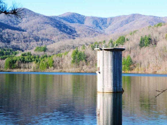 Rocky Branch Lake provides 6,400 Waynesville customers with high-quality drinking water. Cory Vaillancourt photo
Of all the rugged places in Western North Carolina, one of the most pristine and unique is also one of the least known — but that’s by design.
Mention Rocky Branch Lake and you’ll find few who’ve heard of it, and even fewer who’ve actually been to the 86-acre pool that serves as an ample reservoir for the Town of Waynesville’s drinking water. That’s because public access is restricted year-round.
Such has been the case in the 8,030-acre watershed for decades, since the town began acquiring parcels in this isolated mountain valley in the mid-1900s.
Today, however, that valley sits at the intersection of conservation and recreation, as town officials and residents continue to ponder its best and highest use.
Human habitation in the Waynesville watershed likely dates back some 8,000 years; Native Americans hunted and fished the Allens Creek area, leaving traces of their deeds in the form of tools and projectiles, according to Christine Osborne, author of a brief but comprehensive history of the watershed that was released in 2010.


As Europeans made their way to the valley thousands of years later, they established more permanent settlements to take advantage of the deer, grouse, turkey and bear that could be found there, as well as the plentiful trout that still call the crisscrossing network of clean coldwater streams home.
By 1901, two Pennsylvanian lumbermen, Edwin Quinlan and his son Charles, were harvesting more than five million board feet a year of mixed hardwoods like chestnut, hickory, ash and oak from the steep slopes of the valley, supplying not only the Southeast but also insatiable demand from the North.
The largest local deposit of mica, a fire-resistant mineral similar to asbestos, also snakes its way through the area, which in conjunction with large-scale timber harvesting made the whole valley an important economic driver that also employed hundreds of locals.
As Canton’s Champion Paper plant began to grow, harvesting operations in what was now called Quinlantown directly supported the plant until Quinlan’s company mysteriously “faded away” by 1920, according to Osborne.
Three years later, the Town of Waynesville paid $2,043 for 2,043 acres as a hedge against a series of droughts that had recently plagued the region. After World War II, the town began thinning the forest by selling millions of board feet of wood, while the few remaining families and landowners in Quinlantown moved on and moved out.
The town condemned the remaining settlements, and by the late 1950s the area was again largely deserted, although the town continued selling wood through the 1980s.

Early signs of spring appeared at the watershed March 31. Cory Vaillancourt photo
In 1976, a large dam was constructed near the northern edge of the watershed, impounding millions of gallons of water behind the rocky rubble quarried on-site; not long after, the watershed was designated by the State of North Carolina as WS-1, which according to the N.C. Department of Environmental Quality is “High Quality Water” suitable for drinking or in food processing applications for users desiring “maximum protection” of their water.
“Waynesville had the forethought to put this together years ago, to think ahead as far as the water supply is concerned,” said Tim Petrea, a recreation program supervisor with the Town of Waynesville. “They weren’t just thinking for the day, they were thinking for years to come, so we could be assured that our water supply is good, and good quality.”
On March 31, Petrea led a dozen-odd hikers on a guided hike through the watershed — a rare opportunity to see what lies behind Rocky Branch Lake. Petrea’s been with the town for just over five years, but as a hike leader has been through the watershed many times.
There’s really no convenient way to loop back around to the starting point near the town’s water treatment plant, which lies just outside the dam, so the hike ends up being a pleasant 3.5-mile out-and-back along a nicely maintained logging road that lacks any truly steep inclines but peers down through thick stands of rhododendron to babbling brooks bubbling over stairways of well-weathered boulders.
“It’s about getting people of different ages together and getting them out into the wilderness,” Petrea said of the watershed hikes offered through the town’s recreation department just twice a year, once in the spring, and once in the fall. “But for the watershed, it’s about environmental education and teaching stewardship.”
Strict stewardship of the watershed has kept the tract remarkably free of human impact, important in maintaining that WS-1 classification; during the entire five-hour affair, the group removed exactly one piece of litter from the watershed — a bright green plastic soda bottle that may have blown in from up on the Blue Ridge Parkway, which borders the watershed to the south. Aside from that, neither plastic bag nor cigarette butt nor even a bead of Styrofoam was in sight.
Whether the watershed retains that character into the future remains to be seen; sporadic talk of opening the area to various forms of recreation conjures up images of empty beer cans and spent shotgun shells fading in the sun, but the possibility of adding dozens of miles of trails to the town’s park system for hikers, bikers, anglers or hunters is an appealing one both recreationally and economically.
The town, however, has already waded into an aggressive multi-year, multi-million dollar recreation master plan with no real way to pay for it.
That plan doesn’t include the millions it might take to provide safe public access to or parking at the site, or the ongoing maintenance that would soon become necessary.

Early signs of spring appeared at the watershed March 31. Cory Vaillancourt photo
In fact, expanded public access to Rocky Branch Lake seems to be taking a back seat to expanded utilization of the watershed for its primary purpose – serving the town’s 6,400 residential and commercial customers of today and tomorrow.
The Town of Waynesville’s water treatment plant can process up to 7 million gallons of water a day, but on average handles about half that.
Throughout fall 2016, large swaths of the Smokies were parched and/or ablaze; the historic drought and wildfires that season ignited a serious discussion in Haywood County on how the watershed’s output might be regionalized for use in such emergencies.
“Going back to the drought, as the drought deepened [in 2016] we got informal requests from Canton and the Maggie Valley Sanitary District for over 2.5 million gallons of water a day,” Waynesville Town manager Rob Hites told The Smoky Mountain News last year; those requests were in addition to existing service provided to the Junaluska Sanitary District and Lake Junaluska Assembly. “We don’t have the reservoir capacity to sell that much water continually during a protracted drought.”
Over the past 91 years, 13 droughts have affected the watershed, half of them since 1999.
A recent study conducted by engineering firm McGill and Associates on behalf of the town said there’s probably some additional capacity at Rock Branch Lake, almost double the current average yield.
More studies would be needed before any increases would be made, including one on dam stability and presumably others by local, state and federal emergency management agencies.
Given the mechanics of that process, it appears that even if political will is present to either broaden access or increase capacity, Waynesville’s watershed will likely remain unspoiled and inaccessible for years to come.